
|
|
| Coastal Barriers: Protecting people, property, and industry 
Recent updates on the Coastal Barrier System: Texas Monthly story | Texas A&M Galveston story on nature-inspired designs | <|||
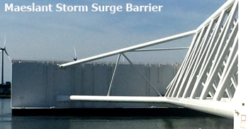 |
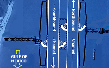
The U.S. Army Corps of Engineers (USACE) is proposing using gate similar to the Maeslant barrier, but smaller, across the Houston Ship Channel at Bolivar Roads (see graphic right). Under the USACE plan there would be two 650 foot gates like the one shown left which would allow for the maintenance and testing of one of the gates while still leaving the channel open to shipping. In the Netherlands when the Maeslant barrier is closed shipping on this channel to the Port of Rotterdam is shutdown. [Learn More] |
 | |
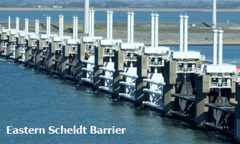 |
The U.S. Army Corps of Engineers is also proposing using 3,900 feet of lift gates similar to those on the Eastern Scheldt barrier in the Netherlands. These gates allow the Dutch to manage the flow of salt water coming from the North Sea and the flow of fresh water from the Rhine thereby allowing them to control the salinity of the water and protecting the mussel and oyster beds behind the barrier. [Learn More] | 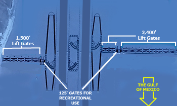 | |
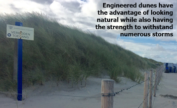 |
The USACE originally proposed constructing the storm surge barrier at major roads in the county. That idea has been modified to place the barrier on the beaches using "natural" dunes. The movement to the beaches is a good one. Dunes can be used to combat storm surge, but if they are constructed of just sand (i.e., "natural dunes") they will last only a few hours during a storm and then will be washed away. A better solution is to use engineered sand dunes that have a solid core in the middle of them and then covered with sand and vegetation. If the sand washes away, the clay/rocks will continue to protect against storm surge especially if it is supported by a large upside down "T" of concrete in the middle of the dune. |  [Learn More] | |
| Other Issues:
Gating San Luis Pass: |
The USACE has decided not to include a gate across San Luis Pass. This is likely to open a back door for storm surge and water to enter Galveston Bay increasing the opportunity for flooding of Galveston Island from the bay side while also increasing water levels in other parts of the bay. We would recommend the USACE do modeling of the impact of having, or not having, gates at this location. From what I saw in the Netherlands, the lift gates used at the Eastern Scheldt barrier might work here. Click on image for a larger view
|
 | |
Other issues: See update on |
At one point the USACE recommended having a high ring levee (over ten feet above ground level) around much of Galveston Island. The concern of some is whether a "fish bowl" effect would be created by having such a levee, especially if we have a rain weather event like Hurricane Harvey. Another concern is whether such a levee would place an obstruction for customers to get to businesses on the bay side of the levee.
|  This Website was created and designed by Website Usability by Design | |
| A final clarification: There have been reports that the cost of building the coastal surge protection system (an Ike Dike) to protect Galveston and the Houston Ship Channel will be in excess of $30 billion. That figure is for construction of surge protection for the entire Texas coast. The cost of protecting the ship channel and the Houston-Galveston region is closer to $10-14 billion. | |||